Vatnajökull National Park

Vatnajökull National Park spans the largest glacier of Iceland, vast highland areas, volcanoes, rivers and lakes.
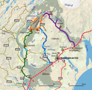
In its southwestern part, Lakagígar is a series of craters formed during the Skaftáreldar eruption in 1783 which left behind lava flows extending over 60 km. In this magnificent area we recommend three routes leading to the Laki craters.
Please note that services in this highland area are limited. You need to bring all provisions, and remember to take enough water from the fords and rest places. There are a few huts and you can put up your tent at the campsite in Blágil which provides water and a shower.
Main Cycling Routes
The Laki circle (39 km)
The heart of the Laki area is encircled by the roads F207 and F206. Within this ring, there are many beautiful volcanic craters. Fragile green moss contrasts with the landscape of black ash and lava. There are interesting hiking trails at the Laki mountain and at the Tjarnargígur crater lake.
The river Varmá which has been displaced by the lava flows is crossed in the western part of road F207. The original path of Varmá was 2 km south of Laki where you can see only a few small streams today.
Water is also available at the rest places at Laki and Tjarnargígur and in Blágil.
The middle route F206 (35 km)
The main access road to Laki is F206. It is quite easy to cycle, the climbs are not too steep, but you need to cross several fords.
The route begins 6 km west of Kirkjubæjarklaustur. After passing the bridge over Skaftá, a 1 km detour to Fjaðrárgljúfur gorge is recommended before continuing north. After the last farm Heiðarsel a track along a power line leading to Leiðólfsfell intersects the F206. Continuing on the main road, you pass a deserted farm, and 1 km farther north you will reach the first of several fords. Geirlandsá is the largest, but usually safe to cross.
North of Geirlandsá, a short detour to the east leads to Fagrifoss, a stunning waterfall. After several smaller fords and Hellisá ford, you reach the Laki circle at the crossroads of roads F206 and F207.
The western route (48 km)
The western route is best to cycle on the return trip from Laki. In this direction, the steep sections are downhill, and there is less danger of getting lost.
In a lava field in the southwest of the Laki circle, turn on a track to the hut Hrossatungur.
After the hut, the route continues to the south, always remain on the main track.
After some streams, the track passes the western side of Leiðólfsfell, where there is accommodation in a turf hut.
1 km farther south, turn left at the power line and follow it to the southeast.
2 km later, you will reach the ford across Hellisá. It is quite shallow and calm and usually easy to cross. The main track continues along the power line until reaching the F206.
Cyclists may turn right 1.5 km after the ford onto a horse riding path which is closed for motorized traffic. You will pass a gate and follow the path to the south.
After 5 km, the track leaves the highland and descends to the farm Skaftárdalur.
From the farm, use the bridge over Skaftá.
After 4 km, you reach road F208 / 208 that connects with road No. 1.
The eastern route (40 km)
This jeep track is not always well-defined, and it has some steep climbs in both directions.
The route begins roughly 0.5 km south of the rest place at Mt. Laki.
The first section (formerly a part of F206) goes eastward along the southern foot of Mt. Laki. Then the track turns left uphill to the northeast.
On the slope of Mt. Blængur, the route turns to the south and descends. After a turnoff to the nearby hut Blængur (closed), the main track continues south, crosses a few streams and aims at Miklafell.
At the mountain, a path to the northeast leads to Laufbalavatn lake. At the lake you can find one of the most remarkable systems of lava caves in Iceland, protected as a natural monument. If you are properly equipped, you may explore these magnificent caves, but take care to not get lost.
The main track turns west around Miklafell, and is rather rough in this section. South of the mountain, a short detour leads to the hut Miklafell (accommodation).
Continuing to south through a lava field, the track improves while descending to the farm Þverá.
After 2 km you finally reach road No. 1 at Orrustuhóll which is a conspicuous tuff “island” in a lava flow ca. 15 km east of Kirkjubæjarklaustur.


